NV5's strategic expansion of its airborne mapping capabilities with the Leica TerrainMapper-3 LiDAR system marks a significant advancement in geospatial intelligence for complex landscapes. This development is critical for the engineering and construction sectors where precision mapping and data reliability are paramount.
What Happened
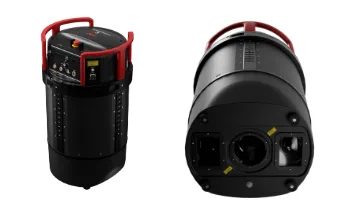
NV5, a prominent US-based provider of compliance and engineering consulting solutions, has integrated the Leica TerrainMapper-3 into its airborne mapping fleet. This integration follows a rigorous real-world evaluation program across varied and challenging terrains, including the Mount Rainier area in Washington State. The Leica TerrainMapper-3, featuring a LiDAR sensor with a 60° field of view and three configurable scan patterns, offers enhanced data capture flexibility. It allows survey teams to adjust scan patterns to suit different terrains, optimizing data acquisition and minimizing the need for multiple flights. The system's integration is complemented by the Leica MFC250 camera system, which enhances image resolution across the LiDAR swath.
The Mount Rainier mapping project demonstrated the system's efficiency in maintaining point density and coverage over large elevation changes, crucial for applications like hazard modeling and emergency planning. The TerrainMapper-3's ability to deliver consistent, high-quality data was further validated by NV5's VP of Data Acquisition, Jon Wittman, who emphasized the importance of reliable acquisition, processing, and manufacturer support.
What This Means for Your Business
For AECM professionals, NV5's adoption of the Leica TerrainMapper-3 underscores the growing importance of advanced LiDAR systems in delivering precise geospatial data. The system's flexible architecture and integrated imaging module provide a competitive edge in mapping complex environments efficiently. This technology not only reduces operational costs by minimizing additional flights but also enhances the quality of deliverables, which is crucial for securing contracts that demand high-precision data.
Moreover, the unified end-to-end workflow offered by Leica Geosystems supports scalable data production, making it an attractive solution for companies looking to streamline their data acquisition and processing operations. The partnership betwe
Is your firm ready for what’s next?
VisioneerIT helps AECM and government contractors modernize operations, achieve compliance, and implement AI.
Explore VisioneerIT Solutions →Tracking the right federal opportunities?
OryonIQ's AI platform monitors agency forecasts, contract awards, and procurement timelines — so government contractors always know what’s coming next.
Try OryonIQ Free →