![IB_KEY_FACTS:[{"stat":"£12,000","label":"Savings on Headstone Manor project","sublabel":"Replaced traditional scaffolding with drone inspections"},{"stat":"Esri UK","label":"Site Scan software powers Harrow's digital twin","sublabel":"Processes unlimited drone data for 2D and 3D outputs"}]](https://www.industrialbriefs.com/favicon.png)
The London Borough of Harrow is pioneering a digital transformation with the integration of a 'digital twin' powered by high-resolution drone imagery. This initiative is not only reducing maintenance costs but also enhancing public engagement with local amenities.
What Happened
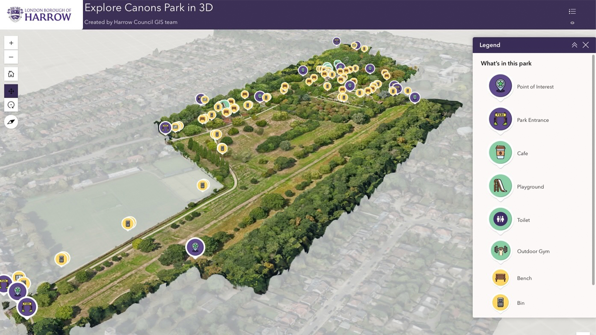
The London Borough of Harrow has launched a digital twin project that leverages high-resolution drone imagery for remote building inspections and public engagement. By employing Esri UK's Site Scan drone software, Harrow is capturing detailed 3D models of various sites, including leisure centers, parks, and historical buildings like the Grade 1 listed Headstone Manor & Museum. This approach replaces traditional scaffolding and manual inspections, exemplified by a £12,000 saving on the Headstone Manor project alone. The initiative is part of the Healthier Harrow programme, which aims to promote healthier lifestyles by encouraging the use of public green spaces through interactive 360-degree imagery.
The project also supports anti fly-tipping efforts by using drones to capture high-resolution 3D images of potential dumping sites. This helps the Environmental team plan more effective preventative measures, such as strategic placement of signage and CCTV. The digital twin builds upon existing low-resolution imagery and integrates with Esri’s GIS system to visualize and analyze the borough’s data, providing a cost-effective hybrid approach to digital representation.
Why It Matters for the AECM Industry
Harrow's use of digital twin technology presents a transformative approach for the AECM industry, particularly in terms of cost savings and efficiency. By utilizing drones for building inspections, the borough significantly reduces the need for costly and time-consuming scaffolding setups. This model can be replicated in other municipalities and private sectors seeking to optimize maintenance budgets.
The integration of high-resolution and low-resolution data offers a scalable solution that maximizes detail where necessary while keeping overall development costs manageable. For engineers and architects, the ability to incorporate detailed 3D models into planning and maintenance tasks supports more informed decision-making.
Additionally, the initiative's public engagement aspect demonstrates how digital twins can serve broader community goals, such as promoting health and wellness through enhanced public space usage. This approach aligns with global trends towards smart city solutions, where technology is leveraged to improve urban living.
What's Next
Harrow plans to expand its digital twin capabilities by automating the integration of Revit BIM models and training additional staff as drone pilots to meet the growing demand for aerial data. Future developments include incorporating real-time data, such as traffic and weather, to further enhance the digital twin's utility. For professionals in the AECM industry, keeping an eye on these advancements could provide insights into evolving best practices and technological applications in urban management.
Is your firm ready for what’s next?
VisioneerIT helps AECM and government contractors modernize operations, achieve compliance, and implement AI.
Explore VisioneerIT Solutions →Tracking the right federal opportunities?
OryonIQ's AI platform monitors agency forecasts, contract awards, and procurement timelines — so government contractors always know what’s coming next.
Try OryonIQ Free →