With the advent of GeoBIM, a collaborative initiative by Esri and Autodesk, the architecture, engineering, and construction (AEC) industry is witnessing a transformation in how geospatial and building information modeling (BIM) data converge. As of June 2025, the integration enables project teams to visualize and manage BIM models within real-world geographic contexts, offering a unified platform for comprehensive project oversight. This development marks a significant stride in bridging the historical divide between GIS and BIM, enhancing collaboration across disciplines that once operated in silos.
What Happened
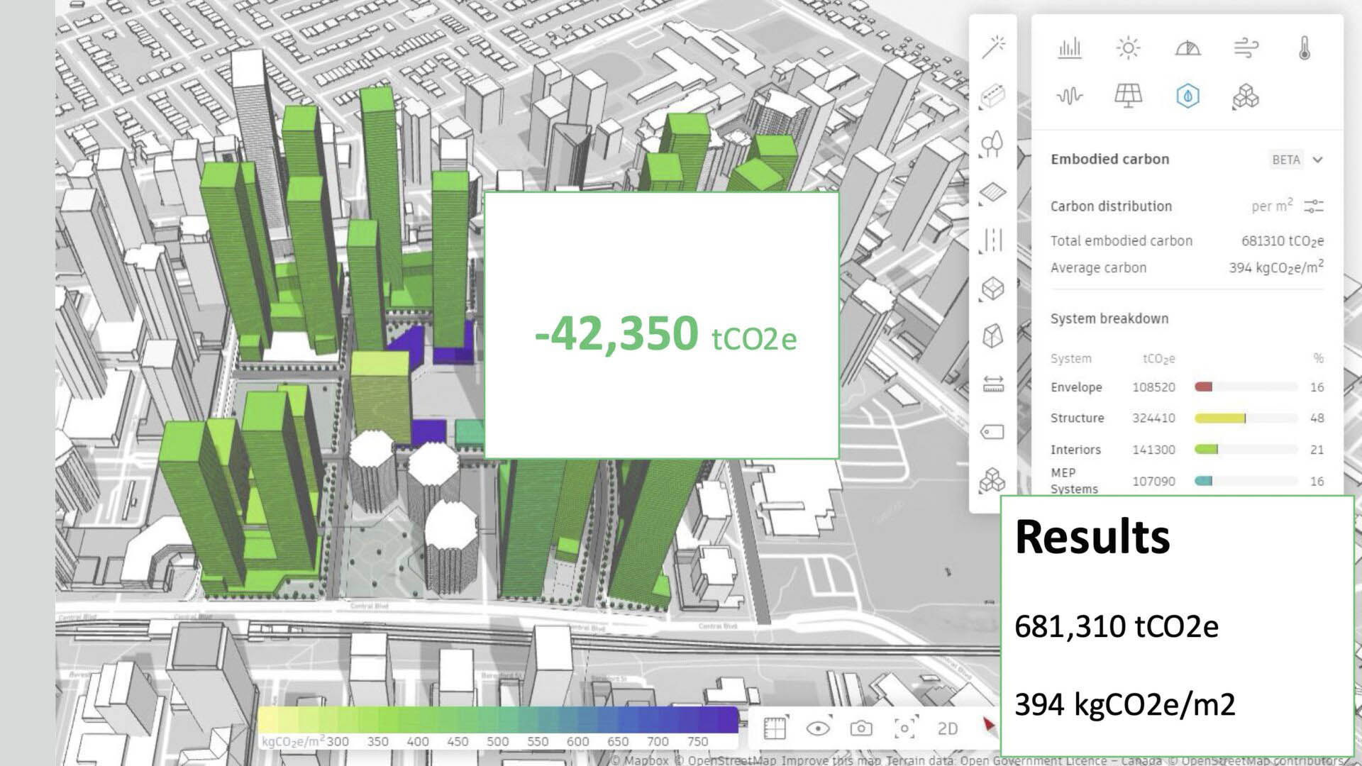
Since 2017, Esri and Autodesk have been working together to create a seamless bridge between GIS and BIM data. This partnership has resulted in the development of ArcGIS GeoBIM, a web-based platform that links Autodesk Construction Cloud (ACC) with Esri's ArcGIS. This integration allows for the visualization, querying, and coordination of BIM models within their geographic context, as explained by Marc Goldman, Esri's director of AEC industry. The technical integration now features two distinct solutions tailored to project needs: Building Layers with ArcGIS Pro for detailed analysis and Simplified 3D Models with ArcGIS GeoBIM for optimized performance and agility.
The collaboration has also led to the introduction of ArcGIS for Autodesk Forma, embedding geospatial reference data into Autodesk’s cloud-based planning platform. This allows users to overlay environmental, infrastructure, zoning, and demographic layers onto early-stage designs, facilitating rapid scenario testing and ensuring spatial consistency across project phases.
Why It Matters for the AECM Industry
The integration of GeoBIM is a game-changer for the AECM industry, addressing several critical challenges. By providing a common dashboard for large-scale projects, it enhances visualization and coordination, which can lead to cost savings and reduced project timelines. The ability to perform element-level analysis and design reviews in a spatially aware environment reduces the risk of errors and rework. Moreover, the seamless integration of GIS data into BIM workflows supports better decision-making and planning, particularly in urban development and infrastructure projects.
For manufacturers, the integration offers opportunities to align product specifications with geographic and environmental data, potentially influencing material choices and logistics. Furthermore, the extended capabilities in scenario testing, such as climate risk assessments, contribute to more sustainable and resilient project outcomes.
What's Next
As Esri continues to deepen its integration with Autodesk's platforms, professionals should keep an eye on further developments in digital twin technologies and AI applications within GeoBIM. The potential evolution of Autodesk Tandem into a multi-building digital twin platform, supported by Esri's GIS context, could redefine asset management and operational efficiencies. Upcoming updates to ArcGIS GeoBIM and Autodesk's cloud solutions will likely introduce new tools and functionalities aimed at enhancing collaborative workflows and data interoperability.
The AECM industry should anticipate continued advancements in the integration of GIS and BIM, which promise to streamline processes, improve project outcomes, and foster a more connected and informed approach to design and construction.
---
Source: https://aecmag.com/geospatial/explorations-in-geobim/
Is your firm ready for what’s next?
VisioneerIT helps AECM and government contractors modernize operations, achieve compliance, and implement AI.
Explore VisioneerIT Solutions →Tracking the right federal opportunities?
OryonIQ's AI platform monitors agency forecasts, contract awards, and procurement timelines — so government contractors always know what’s coming next.
Try OryonIQ Free →